Get a Bird's-Eye View of America's Housing Patterns
See the big picture of how suburban developments are changing the country's landscape, with aerial photos and ideas for the future

Even before Google allowed anybody with an Internet connection to see a satellite view of anyplace on the globe, I loved looking at books with aerial photography. A few favorites that focus on natural and human-made landscapes of the United States are Alex S. MacLean's Designs on the Land: Exploring American from the Air, Dolores Hayden's and photographer Jim Wark's A Field Guide to Sprawl and Alan Berger's Drosscape: Wasting Land in Urban America.
Flipping through these books again recently prompted me to look at America's housing patterns in Google Maps, particularly places for which high-resolution, 45-degree aerial imagery is available. The collected views reveal the diversity of the country's suburban housing in terms of scale and form, but also that much of it is what MacLean describes as "monotonous, sterile, inefficient and pedestrian unfriendly. It is missing a larger plan that goes beyond the responses to market forces, finances and restrictive regulations."
But all hope is not lost, as we'll see. So come along on a trip over America, taking in the good and the bad, the normal and the weird. All the views are at the same scale (a little less than 1/2 mile across).
Suburbia. The suburbs in the United States take many forms, having evolved, like cities, over time from the 19th century to today. This image of Katy, Texas, (near Houston) is of the type that often comes to mind when we think of the suburbs. It is actually a layout that is fairly indicative of developments in the 1960s and '70s. Instead of following a grid, like earlier suburbs did, the streets are curved. But unlike later suburbs, where the cul-de-sac predominates, the streets are interconnected and have only the occasional cul-de-sac.
Suburban-urban grid. As cities grew in the late 19th and early 20th centuries, they tended to follow the grid that Thomas Jefferson laid down in the 18th century. This view of Buffalo, New York, illustrates the adherence to the grid as well as relatively small lots and houses compared to what we see today. Many areas like this were suburban but have since become incorporated into many cities. Their density (number of housing units or residents per acre) is much higher than that of subsequent suburbs. Another major difference occurs in the presence of alleys, which disappeared after the post–World War II boom; nevertheless, we'll see some recent developments later that attempt to bring back alleys for garages and services.
Fairway housing. This view of Bend, Oregon, is fairly typical of suburban houses bordering golf courses. Their fronts face the streets that serve them, while the backs face the fairways and greens of the golf holes. Developments with houses and golf courses are now fairly common. The design of the streets, houses and golf courses have to work together, even though each has its own needs. As I pointed out in an article on walkability, golf course developments are extremely car dependent, given that it is necessary to drive a great distance to get to retail, commercial and other services.
Multifamily island. In the middle of this aerial shot of Bloomington, Indiana, is a multifamily housing development made up of about a dozen apartment buildings. Typical of much of the suburban landscape, the development is segregated from everything that surrounds it, such as the retail on the left. Residents must drive to it via one of two access roads. Note the recreation center with a pool that serves the apartment buildings, as well as the enormous amount of surface parking.
Greenfield housing. One of the most criticized aspects of sprawl is how land previously used for forests and agriculture is developed for housing and roads. This view of Columbus, Ohio, shows some houses that are pushed to the edge (for the time being), probably serving homeowners that can't afford houses closer to urban or other commercial cores. One way to tell this is the "end of the line" is the fact the power lines don't extend to the right.
Correction: The power lines do extend to the right, angled to the south and east.
Correction: The power lines do extend to the right, angled to the south and east.
Fly-in houses. At first this view of Cameron Park, California, may look fairly typical of the suburbs, but a couple of odd things come to the fore: Those roads are mighty wide (compare them with the road at the bottom), and the left-to-right road in the middle of the photo is connected to a runway. Yes, this is a community of fly-in housing, as Alan Berger calls it in his book Drosscape. After landing, residents can park their planes in hangars attached to their houses.
Canal houses. A variation on fairway housing, though not nearly as popular, is canal housing. Just picture the waterways between these houses in Palm Valley, Florida, as fairways. While this sort of plan — where water is used for both recreation and (to a lesser degree) transportation — makes some sense on the Florida coast, it can also be found in the desert Southwest and other areas where water scarcity would point to more suitable alternatives.
Houses on the water. Canal housing may offer the appearance of living on the water, but the previous example shows how the suburban norms (roads, yards) are still maintained. Houseboats, on the other hand, offer the reality of life on the water (waves and all) as well as the ability to move from one slip to another, or even to another city. This "neighborhood" of houseboats in Sausalito, California, is closer to the form of boat docks than suburban sprawl … although I guess each walkway could be seen as a cul-de-sac.
Radiating sprawl. Sun City, Arizona, is arguably the first retirement community in the United States, started in the 1960s near Phoenix. The community has a number of radial "pods" with retail centers, a strip mall in this case. This pod features two types of houses — detached on the left and semidetached on the right — as well as different landscapes to go along with them. I'm guessing the semidetached houses with grass predate the detached houses with xeriscaping, given today's preference for single-family houses and the water problems the desert Southwest has to deal with.
Cul-de-sac segregation. Elsewhere in Sun City, Arizona, is this more widespread form of suburban housing made up of curling streets and cul-de-sacs. What draws my attention is the line in the middle of the photo, where fences separating two developments are casting shadows. This line illustrates how the houses on either side are sequestered from each other by the way the developments are cut up and the roads are laid. A person visiting somebody in the house directly behind them has to drive for five minutes to do so (or hop the fence) because other roads or pedestrian routes are not provided.
Mobile home park. Occupying the middle of this photo is a sizable development of mobile homes, or trailers. It is located in Glenview, Illinois, a suburb north of Chicago near where I grew up. I was always amazed to find mobile homes in the area, and it looks like it has survived the encroachment of semidetached housing and big-box retailers on both sides. Not surprisingly, the mobile homes are not directly connected to either; residents have to use the four-lane road on the right to get anywhere.
Gated community. Less than a mile north of the mobile home park is a much more common type of suburban development, a gated community. The main entrance, and therefore the gate, is located between the two ponds on the right side of this aerial photo. There is one additional way in (at bottom left), but I'm guessing it's for emergencies. So the mixed detached and semidetached houses are connected to the rest of the area via the entrance and the same four-lane road as the mobile home park.
Residential fingers. The sprawl around Phoenix often stops at the bases of mountains, sometimes as hard edges but also as fingers that intertwine with the natural features. Here are a couple of "fingers" in Chandler, south of the city. What I find interesting is that the street on the left does not have direct access to the four-lane road at the bottom; instead residents have to drive through the other finger to go anywhere. Actually, this isn't surprising, given that a close look reveals this to be a small gated community.
Tract mansions. Dolores Hayden, in A Field Guide to Sprawl, defines a tract mansion (her term) as "a large, expensive house [4,000 square feet plus] constructed among homes that are very similar by a subdivider who builds on speculation." These houses in Grand Junction, Colorado, appear to fit the bill. It's hard to miss that each lot has a detention pond, but more subtle is the north–south line between the houses on the left and right; even with curling roads laid out by developers, the Jeffersonian grid is still there.
Transit-oriented development. Alternatives to status quo suburban developments are increasingly popular, though they are hardly realized at close to the same rate. One alternative is the transit-oriented development (TOD), which offers increased density and mixed uses at transit nodes. Highland Gardens Village in Denver, planned by Peter Calthorpe, is billed as a TOD, though the nearby transit is a bus line, which is not as ideal as light rail. This project occupies land that was formerly an amusement park. Now it is a mix of single- and multifamily housing and a network of shared open spaces.
New urbanism. Another alternative is projects that follow the charter of the Congress for the New Urbanism (CNU), "the leading organization promoting walkable, mixed-use neighborhood development, sustainable communities and healthier living conditions," according to the group's website. The most well known CNU developments include Seaside and Celebration, both in Florida, the latter developed by the Walt Disney Company. Also in Florida is the CNU Baldwin Park project in Orlando, shown here, which sits on a former military base. In this view we can see the mixed-use core and the residential in the lower right. Much criticism levied at new urbanism contends that it is suburbia in new (neotraditional) clothes; the street-front buildings hiding interior blocks of surface parking are cases in point.
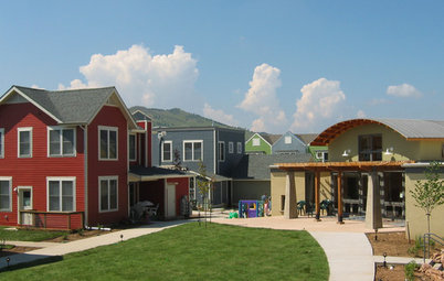
Sustainable urbanism. There is a good deal of overlap between TOD, CNU and sustainable urbanism; each is pitted against suburban sprawl, and each has a good deal of traditional urbanism at its core. Sustainable urbanism "integrates walkable and diverse places with high-performance infrastructure and buildings," per Douglas Farr, the author of Sustainable Urbanism. He highlights the Holiday Neighborhood project in Boulder, Colorado, a mixed-use community planned by Barrett Studio Architects with higher-than-average density for the area. The project features its own green building guidelines, which go beyond the city's own program, and the compact street pattern promotes connection and walking.
These last three examples are markedly different than most of the other patterns shown earlier, indicating that there are choices for those who want to live more responsibly without living in cities. Or to put it another way, there are alternatives to the housing that author Alex MacLean describes as "monotonous, sterile, inefficient and pedestrian unfriendly."
More: Back to the Future of the House


Sponsored

Sponsored