About Us
SpacePhoto is London based measured building survey expert.
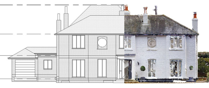
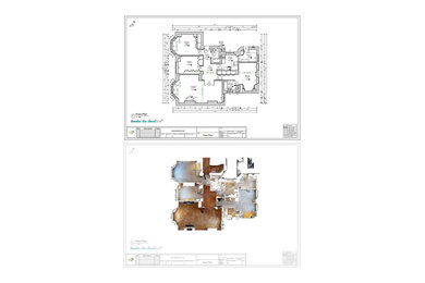
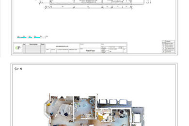
A measured building survey is an accurate representation of a building.
SpacePhoto Team undertakes measured building surveys or as-built surveys using the latest 3D laser scanning technology.
These innovative tools are time and cost-saving, accurate, and they eliminate the possibility of human error in recordings.
This allows us to provide our clients with precise and easy-to-use 2D drawings, sections, and elevations in different formats.
These may include Revit, CAD, and PDF drawings.
The outputs from the site visit are as follows:
2D Floor Plans (DWG and PDF)
Roof Plans
Block Plan (Boundary, Trees, Manholes)
Topography (Boundary, Trees, Manholes, Levels)
Internal and External Elevations
Cross Sections Drawings
3D virtual tour
3D Revit model (2021 RVT File format)
SpacePhoto works with architects, homeowners, property developers, and construction companies providing them surveys for:
Property developments
Building applications
Project design and renovation
As-Built documentation drawings
SpacePhoto is based in London, however, we travel anywhere in the UK for our site surveys.
Services Provided
Architectural Drawings, House Plans, Land Surveying, Building Drawings, Surveys, Property Photography
Areas Served
London, United Kingdom
Category
Back to Navigation
Business Details
Business Name
SpacePhoto
Phone Number
020 3287 6610
Website
Address
SE24
London, Greater London SE24 9HN
United Kingdom
Followers
Back to Navigation
Credentials
1 Houzz Badge
Back to Navigation


Back to Navigation
5 Ideabooks
Contact SpacePhoto
Thank you for the review :) likewise it is our pleasure to work with Sevenoaks Plans LTD great communication and great workflow, they know what they do :)
Thanks
Peter